Massacre of Glencoe
The Massacre of Glencoe took place in Glencoe on the 13 February 1692, following the Jacobite uprising of 1689-92. An estimated 30 members and associates of Clan MacDonald of Glencoe were killed by government forces billeted with them, on the grounds they had not been prompt in pledging allegiance to the new monarchs, William III of England and Mary II.
Landscape and scenery.
Although named after Ben Nevis and Glencoe, the National Scenic Area covers a much wider area of land, as detailed below. Much of the northern part of the NSA lies within the Lochaber region.

Glen Coe,
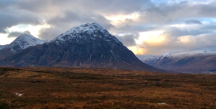
Glencoe is a glen of volcanic origins, in the heart of the National Scenic Area. A review of the National Scenic Areas by Scottish Natural Heritage in 2010 made reference to the “soaring, dramatic splendour of Glencoe”, and “the suddenness of the transition between high mountain pass and the lightly wooded strath” in the lower glen. It also described the journey through the glen on the main A82 road as “one of the classic Highland journeys”. The main settlement is the village of Glencoe located at the foot of the glen. The glen is regarded as the home of Scottish mountaineering and is popular with hillwalkers and climbers.
Glen Nevis
Glen Nevis lies in the north of the national scenic area, and runs south from Fort William. It is bordered to the south by the Mamore range, and to the north by the highest mountains in Britain: Ben Nevis (Scotland’s highest mountain), Carn Mor Dearg, Aonach Mor, and Aonach Beag,.It is home to the second highest waterfall in Scotland, Steall Falls. Below the waterfall is a steeply walled and impressive gorge.
Mamores
The Mamores form an east-west ridge approximately fifteen kilometres in length lying between Glen Nevis to the north and Loch Leven to the south. Ten of the ranges are classified as Munros. The hills can be accessed from both Glen Nevis and the former aluminium smelting town of Kinlochleven.
Glen Etive
Glen Etive lies to the south of Glencoe. The River Etive rises on the peaks surrounding Rannoch Moor, with several tributary streams coming together at the newly refurbished Kings House Hotel. From the Kings House, the Etive flows for about 18 km, reaching the sea loch, Loch Etive. The river and its tributaries are popular with whitewater kayakers and at high water levels it is a test piece of the area and a classic run. Glen Etive has been used as the backdrop to many movies, among them Braveheart and Skyfall.
The Black Mount
The Black Mount is situated between Glen Orchy and Glencoe, to the east of Glen Etive, forming the southernmost part of the national scenic area. Its four Munros are Stob Ghabhar, Stob a Choire Odhair, Creise and Meall a Bhuiridh. The hills of Ben Inverveigh and Meall Tairbh are located between Black Mount and the Bridge of Orchy. The Black Mount Deer Forest includes Moorland, the mountain, as well as several rivers, burns, lochs, and tarns.
Rannoch Moor
Much of the western part of Rannoch Moor, an expanse of around 50 square miles (130 km²) of boggy moorland to the west of Loch Rannoch in Scotland, is included in the national scenic area. The A82 road crosses western Rannoch Moor on its way to Glencoe and Fort William, as does the West Highland Way, which reaches Fort William via Glen Spean rather than Glencoe. When the line was built across the moor, its builders had to float the tracks on a mattress of tree roots, brushwood and thousands of tons of earth and ashes. Corrour railways station, the UK’s highest, and one of its most remote being 10 miles (16 km) from the nearest public road, is located on this section of the line at 1,339 feet (408 m). The line takes gentle curves totalling 23 miles (37 km) across the moorland.
Conservations designations
A number of other conservation designation are defined within or overlapping with the NSA: Glencoe is designated as a both national nature reserve (NNR), and a Special Area of Conservation (SAC) due to wide variety of montane habitats found within the glen. Glencoe, along with most of the southwestern portion of the NSA including Glen Etive and the Black Mount, forms part of the Glen Etive and Glen Fyne Special Protection Area (SPA), which is protected due to its breeding population of Golden Eagles.
Rannoch Moor is also designated as an SAC, and is particularly famous as being the sole British location for the Rannoch-Rush, named after the moor. It also has populations of Otters and Freshwater Pearl Mussels. The River Tay rises on the moor within the NSA, and is designated as a separate SAC for its entire length. The Ben Nevis massif is also an SAC, as are the woodlands at North Ballachulish in the westernmost part of the NSA. The final SAC within the NSA protects the woods on the western side of Loch Etive, in the southwestern extremity of the area.
Buachaille Etive Mor lies close to the head of both Glen Coe and Glen Etive, on the edge of Rannoch Moor.